Marcio Nogueira Barbosa
Diretor / Director INPE
![]()
![]()
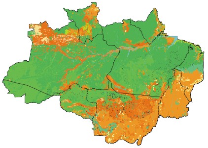
| Monitoramento
do Desflorestamento Bruto da Amazônia Brasileira
PRODES é considerado o maior projeto de monitoramento de florestas do mundo utilizando técnicas de sensoriamento remoto por satélite.
O Instituto Nacional de Pesquisas Espaciais, INPE,
há muitos anos
promove a interpretação de imagens do satélite
norte
americano Landsat para acompanhar a
evolução do desflorestamento bruto
da Amazônia brasileira. Este esforço
gerou resultados para
o período de 1974 a 1996.
O presente estudo, relativo
aos anos de 1997 ( estimativa
O trabalho ora apresentado exigiu o
esforço de aproximadamente 50.000 pessoas x hora e 10.000 horas
x máquina, e investimentos
A divulgação destes dados
evidencia o compromisso do Governo Federal em tratar com transparência
as informações relativas ao desflorestamento
bruto da Amazônia. Além
disso, fornece
|
Monitoring
the Brazilian Amazon Gross Deforestation
PRODES is the largest forest monitoring
project in the world, based on orbital remote sensing. For many years
the National Institute for Space Research, INPE, has been promoting
the interpretation of images from the U.S. Landsat
satellite to monitor the evolution of the extent and rate
of gross deforestation in the Brazilian Amazon.
The present study, covering
the years of 1997 (estimate based on The work required approximately 50,000 person x hours and 10,000 machine x hours, at a cost of US$ 1,5 million. The provision of systematic information
over critical areas in the Amazon is a
direct contribution of the Ministry of
Science and Technology, through INPE, to
environmental control agencies,
The presentation of these results
clearly indicates the commitment |
Marcio Nogueira Barbosa
Diretor / Director INPE
![]()
![]()