|
|
|
| O PRODES, além de fornecer
estimativas da extensão e taxa média do desflorestamento
bruto, indica geograficamente as áreas mais críticas. Por
exemplo, em 1998, mais de 78 % do desflorestamento bruto na Amazônia
concentrou-se em 44 das 229 imagens do satélite Landsat.
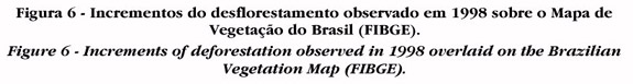
Adicionalmente, os dados do PRODES são sobrepostos ao Mapa de Vegetação do RADAM (FIBGE) (Figura 6), para identificar as fisionomias florestais alteradas (Figura 7). |
PRODES, in addition to the extent and rate of gross deforestation, provides the spatial distribution of critical areas in the Amazon. For instance, in 1998, more than 78 % of the deforestation was concentrated in 44 of the satellite images analysed. PRODES data are overlaid on the Vegetation Map from the RADAMBRASIL Project - FIBEG (Figure 6) to identify the forest physiognomies affected by anthropogenic activities (Figure 7). | |
 |
||
 |
||